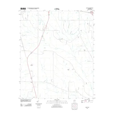
2012 Map of Egypt
USGS Topo · Published 2012About this map
Egypt and the small settlement of Black Belt anchor this Chickasaw County landscape, where the prairie topography is defined by the complex branching of Mattubby Cr and its many tributaries. The area is notable for its concentration of family and community burial grounds, such as Pleasant Valley Cem, Old Union Cem, and Ware Hill Cem, which sit alongside historic road traces like Old Highway 41. The map reveals a rural economy supported by local aviation, marked by both Leuth Flying Service Airport and Ball Airport. The drainage patterns of Sadler Cr, Miller Cr, and Cedar Cr illustrate the natural irrigation of this section of the Mississippi Black Prairie, providing a clear view of the land divisions and secondary roads like Clopton Sykes Rd and Darden Chapel Rd that connect these agricultural communities.
Find a feature on this map
68 named features on this map. Tap any name to fly to it.
Don’t see what you’re looking for? This feature index may not catch every label — zoom into the map to look around manually.
Map Details
Editions of this 2012 Egypt Map
This is the sole edition of this map. No revisions or reprints were ever made.
Other maps of this area

1953 · West Point
USGS Topo · 1:250,000

1956 · Tupelo
USGS Topo · 1:250,000

1958 · Tupelo
USGS Topo · 1:250,000

1958 · West Point
USGS Topo · 1:250,000

1959 · Van Vleet
USGS Topo · 1:62,500

1963 · West Point
USGS Topo · 1:250,000

1965 · Egypt
USGS Topo · 1:24,000

1966 · Aberdeen
USGS Topo · 1:24,000

1966 · Shannon
USGS Topo · 1:24,000

1966 · Wren
USGS Topo · 1:24,000