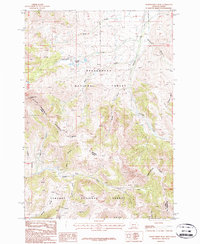
1987 Map of Eighteenmile Peak
USGS Topo · Published 1987About this map
The Continental Divide serves as the high-altitude spine of this landscape, marking the boundary between the Beaverhead National Forest in Montana and the Targhee National Forest in Idaho. At the heart of this survey is Eighteenmile Peak, a prominent landmark surrounded by a network of drainage systems including Rock Creek, Nicholia Creek, and Cottonwood Creek. The high-country terrain is punctuated by deep depressions like Milo Canyon and Eidelman Canyon. Evidence of early resource exploration is documented through several marked Prospects and a specific Prospect located near the headwaters of Smelter Gulch and Cedar Gulch. Small alpine water bodies, specifically the Harkness Lakes, sit high above the valleys, illustrating the complex hydrology of this mountainous border region during the late twentieth century.
Find a feature on this map
21 named features on this map. Tap any name to fly to it.
Don’t see what you’re looking for? This feature index may not catch every label — zoom into the map to look around manually.
Map Details
Editions of this 1987 Eighteenmile Peak Map
2 editions found
Other maps of this area

1955 · Dubois
USGS Topo · 1:250,000

1956 · Morrison Lake
USGS Topo · 1:62,500

1956 · Nicholia
USGS Topo · 1:62,500

1957 · Scott Peak
USGS Topo · 1:62,500

1958 · Dubois
USGS Topo · 1:250,000

1965 · Caboose Canyon
USGS Topo · 1:24,000

1965 · Island Butte
USGS Topo · 1:24,000

1980 · Leadore
USGS Topo · 1:100,000

1983 · Dubois
USGS Topo · 1:100,000
1987 · Eighteenmile Peak
USGS Topo · 1:24,000