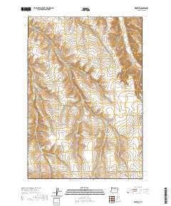
2020 Map of Eightmile
USGS Topo · Published 2020About this map
Eightmile and the surrounding rangeland of Morrow County are defined by a complex network of canyons and drainage basins that have shaped local settlement patterns for generations. The landscape is punctuated by numerous named canyons, including Eightmile Canyon, Keck Canyon, and Robinson Canyon, which direct the flow of intermittent streams toward Rhea Cr in the northeast. This topography required a winding road system, represented here by routes like Valby Rd and Liberty School Rd.
Find a feature on this map
34 named features on this map. Tap any name to fly to it.
Don’t see what you’re looking for? This feature index may not catch every label — zoom into the map to look around manually.
Map Details
Editions of this 2020 Eightmile Map
This is the sole edition of this map. No revisions or reprints were ever made.
Other maps of this area

1953 · Pendleton
USGS Topo · 1:250,000

1956 · Pendleton
USGS Topo · 1:250,000

1968 · Gooseberry
USGS Topo · 1:24,000

1968 · Lexington
USGS Topo · 1:24,000

1968 · Eightmile
USGS Topo · 1:24,000
1968 · Utts Butte
USGS Topo · 1:24,000

1968 · Ruggs
USGS Topo · 1:24,000

1968 · Ione South
USGS Topo · 1:24,000

1969 · Buttermilk Canyon
USGS Topo · 1:24,000

1969 · Hardman
USGS Topo · 1:24,000