
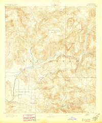
1893 Map of El Cajon
USGS Topo · Published 1893About this map
The El Cajon Valley serves as the focal point for this late-nineteenth-century study of the eastern San Diego hinterlands. Settlement clusters around the San Diego Cuyamaca and Eastern Railway, which terminates at Foster, indicating a landscape transitioning into an agricultural and transit hub. A critical piece of regional infrastructure, the San Diego Flume, snakes through the central hills, navigating the terrain via a series of engineering feats including the Cape Horn Tunnel, Monte Tunnel, and Los Coches Tunnel. This complex water system, alongside the San Diego River, underscores the era's intensive efforts to manage water for valley development. Away from the rail line, smaller outposts like Alpine and Dehesa sit near the Sweetwater River, while Cycuan Pk. and El Cajon Mt. dominate the horizon. The presence of Lindo Lake at Lakeside suggests early recreational and residential draws to the area.
Find a feature on this map
36 named features on this map. Tap any name to fly to it.
Don’t see what you’re looking for? This feature index may not catch every label — zoom into the map to look around manually.
Map Details
Editions of this 1893 El Cajon Map
2 editions found
Other maps of this area

1893 · Escondido
USGS Topo · 1:62,500

1901 · Elcajon
USGS Topo · 1:62,500

1901 · Escondido
USGS Topo · 1:62,500

1901 · San Luis Rey
USGS Topo · 1:125,000

1903 · Cuyamaca
USGS Topo · 1:125,000

1903 · La Jolla
USGS Topo · 1:62,500

1903 · Elcajon
USGS Topo · 1:62,500

1903 · Ramona
USGS Topo · 1:125,000

1904 · San Diego
USGS Topo · 1:62,500

1904 · Southern California Sheet No. 2
USGS Topo · 1:250,000