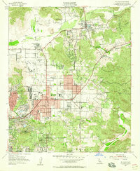
1955 Map of El Cajon
USGS Topo · Published 1959About this map
El Cajon and its surrounding valleys are captured here in the mid-1950s, a period of transition where the agricultural roots of the region meet post-war suburban and industrial growth. The landscape is dotted with specialized institutions and landmarks like Edgemoor County Farm, Maniscalcos Cactus Farm, and the prominent Gillespie Field with its accompanying Airway Beacon. Local transit and trade are anchored by the San Diego and Arizona Eastern railroad, which threads through the city center past Cuyamaca Sch and the El Cajon Cem.
Find a feature on this map
63 named features on this map. Tap any name to fly to it.
Don’t see what you’re looking for? This feature index may not catch every label — zoom into the map to look around manually.
Map Details
Editions of this 1955 El Cajon Map
2 editions found
Other maps of this area

1893 · El Cajon
USGS Topo · 1:62,500

1901 · Elcajon
USGS Topo · 1:62,500

1903 · Cuyamaca
USGS Topo · 1:125,000

1903 · La Jolla
USGS Topo · 1:62,500

1903 · Elcajon
USGS Topo · 1:62,500

1904 · San Diego
USGS Topo · 1:62,500

1904 · Southern California Sheet No. 2
USGS Topo · 1:250,000

1930 · La Jolla
USGS Topo · 1:62,500

1930 · San Diego
USGS Topo · 1:62,500

1939 · El Cajon
USGS Topo · 1:62,500