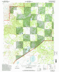
1995 Map of El Dado Mesa
USGS Topo · Published 1998About this map
The high desert landscape of El Dado Mesa is defined by a complex network of seasonal water catchments and historic land divisions in New Mexico's McKinley County. The map details a transition from the elevated Chivato Ridge down toward the Cebolleta Grant boundary, where an extensive collection of livestock tanks and natural basins like Laguna Grande and Laguna de Alejandro support the high-altitude ranching economy. This 1990s survey preserves the placement of isolated structures like the Ranger Cabin and Grande Camp, alongside named springs such as Ojo del Dado and La Vent Spring. The terrain is deeply incised by drainages like the Cañon del Dado and Arroyo Cañoneros, illustrating the vital importance of water management in the Cibola National Forest through features like the Alejandro Water Tank and Heller Tank.
Find a feature on this map
36 named features on this map. Tap any name to fly to it.
Don’t see what you’re looking for? This feature index may not catch every label — zoom into the map to look around manually.
Map Details
Editions of this 1995 El Dado Mesa Map
This is the sole edition of this map. No revisions or reprints were ever made.
Other maps of this area

1883 · Mt. Taylor
USGS Topo · 1:250,000

1886 · Mt. Taylor
USGS Topo · 1:250,000

1892 · Mt. Taylor
USGS Topo · 1:250,000

1899 · Mt. Taylor
USGS Topo · 1:250,000

1958 · Albuquerque
USGS Topo · 1:250,000

1961 · Marquez
USGS Topo · 1:24,000

1961 · El Dado
USGS Topo · 1:24,000

1961 · Cerro Parido
USGS Topo · 1:24,000

1961 · El Dado Mesa
USGS Topo · 1:24,000
1961 · Laguna Seca
USGS Topo · 1:24,000