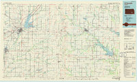
1985 Map of El Dorado
USGS Topo · Published 1985About this map
The Walnut River and the reservoir at El Dorado Lake define the western landscape of this mid-1980s survey, while the Fall River Lake anchors the eastern reaches. The region is a dense network of transit and hydrology, where the Kansas Turnpike and several major rail lines including the Atchison Topeka and Santa Fe and Missouri Pacific intersect near El Dorado. These corridors connect a string of smaller settlements like Rosalia, Sallyards, and Beaumont, reflecting the historical importance of rail-to-road commerce across the Flint Hills.
Find a feature on this map
118 named features on this map. Tap any name to fly to it.
Don’t see what you’re looking for? This feature index may not catch every label — zoom into the map to look around manually.
Map Details
Editions of this 1985 El Dorado Map
This is the sole edition of this map. No revisions or reprints were ever made.
Other maps of this area

1885 · Burlington
USGS Topo · 1:125,000

1885 · Eureka
USGS Topo · 1:125,000

1885 · Sedan
USGS Topo · 1:125,000

1886 · Fredonia
USGS Topo · 1:125,000

1886 · Independence
USGS Topo · 1:125,000

1888 · Emporia
USGS Topo · 1:125,000

1888 · Eureka
USGS Topo · 1:125,000

1888 · Eldorado
USGS Topo · 1:125,000

1889 · Newton
USGS Topo · 1:125,000

1889 · Burden
USGS Topo · 1:125,000