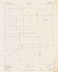
1968 Map of El Mirage
USGS Topo · Published 1969About this map
The high desert landscape of El Mirage Valley straddles the boundary between Los Angeles and San Bernardino counties during a period of transition in the late 1960s. The small settlement of El Mirage sits at the edge of this arid expanse, where sparse water sources like Moody Springs and Eller Slough supported early habitation. The terrain is defined by prominent volcanic-like peaks such as Black Butte, Mt Elmo, and the Three Sisters.
Find a feature on this map
28 named features on this map. Tap any name to fly to it.
Don’t see what you’re looking for? This feature index may not catch every label — zoom into the map to look around manually.
Map Details
Editions of this 1968 El Mirage Map
This is the sole edition of this map. No revisions or reprints were ever made.
Other maps of this area

1901 · Southern California Sheet No. 1
USGS Topo · 1:250,000

1903 · Rock Creek
USGS Topo · 1:62,500

1903 · San Antonio
USGS Topo · 1:62,500

1904 · Southern California Sheet No. 1
USGS Topo · 1:250,000

1930 · Black Butte
USGS Topo · 1:24,000

1930 · El Mirage
USGS Topo · 1:24,000

1930 · Angle
USGS Topo · 1:24,000

1930 · Wilsona
USGS Topo · 1:24,000

1932 · Angle
USGS Topo · 1:24,000

1933 · El Mirage
USGS Topo · 1:24,000