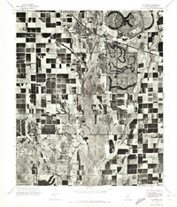
1971 Map of El Mirage
USGS Topo · Published 1971About this map
The Agua Fria River bisects this landscape, revealing a stark contrast between established agricultural grids and the emerging circular geometry of mid-century planned communities. El Mirage and Youngtown occupy the central transition between the river's wide, braided channel and the dense development to the east. The most striking visual element is the master-planned layout of Sun City, featuring its iconic concentric ring roads and winding residential streets that break the traditional rectangular desert survey. On the western edge, the massive footprint of Luke Air Force Base stands as a significant military installation, overlooking the sprawling irrigated fields that dominated this part of Maricopa County before the rapid suburban expansion of the early 1970s.
Find a feature on this map
5 named features on this map. Tap any name to fly to it.
Don’t see what you’re looking for? This feature index may not catch every label — zoom into the map to look around manually.
Map Details
Editions of this 1971 El Mirage Map
This is the sole edition of this map. No revisions or reprints were ever made.
Other maps of this area

1912 · Phoenix
USGS Topo · 1:62,500

1914 · Phoenix
USGS Topo · 1:62,500

1946 · Avondale
USGS Topo · 1:62,500

1948 · Cashion
USGS Topo · 1:62,500

1952 · Fowler
USGS Topo · 1:24,000

1952 · Phoenix
USGS Topo · 1:62,500

1954 · Phoenix
USGS Topo · 1:250,000

1957 · Phoenix
USGS Topo · 1:250,000

1957 · Perryville
USGS Topo · 1:24,000

1957 · Calderwood Butte
USGS Topo · 1:24,000