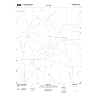
2010 Map of El Morro Mesa
USGS Topo · Published 2010About this map
El Morro Mesa dominates the central landscape of this De Baca County territory, rising above the surrounding high plains. In the early 21st century, the area remains defined by its ranching history, with Overton Ranch and Jasper Ranch serving as primary landmarks within the wide expanse of Gramma Valley. The drainage of Yeso Creek cuts across the northern section of the map, providing a vital water source in this arid region. The network of county roads, including Scorpian Rd and County Rd-1-16, traces the paths between distant plateaus like Conejo Mesa, illustrating the low-density settlement patterns and extensive land use typical of eastern New Mexico. This map records a landscape where the terrain itself dictates the location of roads and homesteads.
Find a feature on this map
14 named features on this map. Tap any name to fly to it.
Don’t see what you’re looking for? This feature index may not catch every label — zoom into the map to look around manually.
Map Details
Editions of this 2010 El Morro Mesa Map
This is the sole edition of this map. No revisions or reprints were ever made.
Other maps of this area

1954 · Fort Sumner
USGS Topo · 1:250,000

1958 · Fort Sumner
USGS Topo · 1:250,000

1966 · El Morro Mesa
USGS Topo · 1:24,000

1966 · Horney Ranch
USGS Topo · 1:24,000

1966 · Yeso
USGS Topo · 1:24,000

1966 · Yeso NW
USGS Topo · 1:24,000

1967 · Dunlap NE
USGS Topo · 1:24,000
1967 · The Old Dry Lake
USGS Topo · 1:24,000

1967 · Wright Ranch
USGS Topo · 1:24,000

1979 · Fort Sumner
USGS Topo · 1:100,000