
1966 Map of El Morro Mesa
USGS Topo · Published 1968About this map
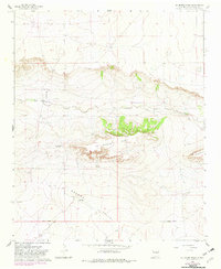
El Morro Mesa dominates this central De Baca County landscape, rising between the drainage of Yeso Creek and the broad expanse of Gramma Valley. In the mid-1960s, this area remained sparsely populated, characterized by isolated holdings such as the Overton Ranch and Jasper Ranch. The presence of a dedicated Landing Strip near the northern bluff indicates the reliance on aerial access for these remote ranching operations. The map also records the location of unidentified Ruins along the creek, suggesting a history of habitation preceding the modern ranching era. This survey, compiled from 1965 aerial photography, provides a clear view of the complex topography including Conejo Mesa and the surveyed Base Line that anchors the region's township grid.
Find a feature on this map
15 named features on this map. Tap any name to fly to it.
Don’t see what you’re looking for? This feature index may not catch every label — zoom into the map to look around manually.
Map Details
Editions of this 1966 El Morro Mesa Map
2 editions found
Other maps of this area

1954 · Fort Sumner
USGS Topo · 1:250,000

1958 · Fort Sumner
USGS Topo · 1:250,000

1966 · Horney Ranch
USGS Topo · 1:24,000

1966 · Yeso
USGS Topo · 1:24,000

1966 · Yeso NW
USGS Topo · 1:24,000

1967 · Dunlap NE
USGS Topo · 1:24,000
1967 · The Old Dry Lake
USGS Topo · 1:24,000

1967 · Wright Ranch
USGS Topo · 1:24,000

1979 · Fort Sumner
USGS Topo · 1:100,000

1981 · Yeso Mesa
USGS Topo · 1:24,000