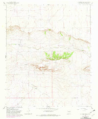
1966 Map of El Morro Mesa
USGS Topo · Published 1982About this map
El Morro Mesa dominates the central landscape of this De Baca County region, rising above the surrounding high plains and drainage systems. The map captures a moment in the mid-1960s where the sparse settlement pattern of eastern New Mexico is defined by isolated outposts such as Overton Ranch and Jasper Ranch. To the south, Gramma Valley opens up, while Yeso Creek cuts through the northern sections, providing a critical water source in this arid environment.
Find a feature on this map
16 named features on this map. Tap any name to fly to it.
Don’t see what you’re looking for? This feature index may not catch every label — zoom into the map to look around manually.
Map Details
Editions of this 1966 El Morro Mesa Map
2 editions found
Other maps of this area

1954 · Fort Sumner
USGS Topo · 1:250,000

1958 · Fort Sumner
USGS Topo · 1:250,000

1966 · El Morro Mesa
USGS Topo · 1:24,000

1966 · Horney Ranch
USGS Topo · 1:24,000

1966 · Yeso
USGS Topo · 1:24,000

1966 · Yeso NW
USGS Topo · 1:24,000

1967 · Dunlap NE
USGS Topo · 1:24,000
1967 · The Old Dry Lake
USGS Topo · 1:24,000

1967 · Wright Ranch
USGS Topo · 1:24,000

1979 · Fort Sumner
USGS Topo · 1:100,000