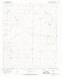
1967 Map of The Old Dry Lake
USGS Topo · Published 1971About this map
The Old Dry Lake sits at the center of this high plains drainage network in De Baca County, where the 1960s landscape was defined by an extensive system of water management for ranching. The terrain is deeply etched by ephemeral watercourses such as Ragland Draw and Indian Draw, which funnel seasonal runoff toward the basin. The distribution of scattered water sources suggests a carefully maintained grazing economy, with family-named or functional landmarks like O'Brian Tank, Heifer Tank, and the School Section Tank providing critical infrastructure across the sections.
Find a feature on this map
27 named features on this map. Tap any name to fly to it.
Don’t see what you’re looking for? This feature index may not catch every label — zoom into the map to look around manually.
Map Details
Editions of this 1967 The Old Dry Lake Map
This is the sole edition of this map. No revisions or reprints were ever made.
Other maps of this area

1954 · Fort Sumner
USGS Topo · 1:250,000

1958 · Fort Sumner
USGS Topo · 1:250,000

1966 · El Morro Mesa
USGS Topo · 1:24,000

1966 · Horney Ranch
USGS Topo · 1:24,000

1967 · Wire Lake
USGS Topo · 1:24,000

1967 · Dunlap NE
USGS Topo · 1:24,000

1967 · Devils Well
USGS Topo · 1:24,000
1967 · Dunlap
USGS Topo · 1:24,000

1967 · Wright Ranch
USGS Topo · 1:24,000

1979 · Fort Sumner
USGS Topo · 1:100,000