
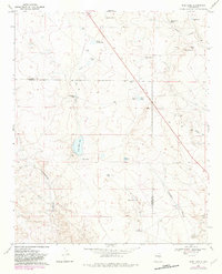
1967 Map of Wire Lake
USGS Topo · Published 1971About this map
Halfway House Ranch and Wright Ranch anchor this landscape of the High Plains along the border of De Baca and Chaves counties. The area is defined by a critical network of water management features essential for ranching in this arid environment, ranging from natural catchments like North Home Lake, South Home Lake, and Wire Lake to numerous named tanks such as Sons Tank and Sally Tank. The topography is marked by significant drainage systems including Burro Draw and Fifteenmile Arroyo, which cut through the terrain toward the lower elevations. Near the northern boundary, the presence of a Gravel Pit and a Pipeline suggest the sparse but vital industrial activity of the mid-20th century. Local landmarks like Burro Hill and Burro Spring provide specific points of interest for those tracing the historic land use and boundary lines of these New Mexico ranch lands.
Find a feature on this map
31 named features on this map. Tap any name to fly to it.
Don’t see what you’re looking for? This feature index may not catch every label — zoom into the map to look around manually.
Map Details
Editions of this 1967 Wire Lake Map
2 editions found
Other maps of this area

1954 · Fort Sumner
USGS Topo · 1:250,000

1955 · Roswell
USGS Topo · 1:250,000

1958 · Fort Sumner
USGS Topo · 1:250,000

1958 · Roswell
USGS Topo · 1:250,000

1962 · Roswell
USGS Topo · 1:250,000

1967 · Round Mountain
USGS Topo · 1:24,000

1967 · Chivata Canyon
USGS Topo · 1:24,000

1967 · Devils Well
USGS Topo · 1:24,000

1967 · Ramon
USGS Topo · 1:24,000

1967 · Ramon SW
USGS Topo · 1:24,000