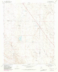
1967 Map of Wire Lake
USGS Topo · Published 1982About this map
Halfway House Ranch and Boot Ranch anchor this landscape along the border of Chaves and De Baca counties, where the high plains topography is defined by a critical network of livestock tanks and seasonal lakes. The presence of Wire Lake, North Home Lake, and South Home Lake indicates a reliance on these water catchment systems in an arid environment. A distinct Pipeline cuts across the southern terrain, reflecting 20th-century utility development alongside older ranching infrastructure.
Find a feature on this map
32 named features on this map. Tap any name to fly to it.
Don’t see what you’re looking for? This feature index may not catch every label — zoom into the map to look around manually.
Map Details
Editions of this 1967 Wire Lake Map
2 editions found
Other maps of this area

1954 · Fort Sumner
USGS Topo · 1:250,000

1955 · Roswell
USGS Topo · 1:250,000

1958 · Fort Sumner
USGS Topo · 1:250,000

1958 · Roswell
USGS Topo · 1:250,000

1962 · Roswell
USGS Topo · 1:250,000

1967 · Wire Lake
USGS Topo · 1:24,000

1967 · Round Mountain
USGS Topo · 1:24,000

1967 · Chivata Canyon
USGS Topo · 1:24,000

1967 · Devils Well
USGS Topo · 1:24,000

1967 · Ramon
USGS Topo · 1:24,000