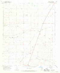
1967 Map of Dunlap
USGS Topo · Published 1971About this map
Arroyo de la Mora cuts a wide path through this high plains landscape of De Baca County, revealing a ranching economy centered on scattered water sources and historic transit routes. The presence of the Old Military Road provides a tangible link to 19th-century frontier movement, crossing the landscape near Mora Springs. The map documents a network of named water tanks and windmills essential for survival and livestock in this arid environment, such as Grasshopper Tank and King Windmill. Small ranching hubs like Key Ranch and Martin Ranch anchor the remote terrain, while the locality of Dunlap sits near the northeastern edge. This survey, based on 1966 aerial photography, preserves the specific locations of isolated improvements like Stinson and Sheppard Windmill that defined rural New Mexico life in the mid-20th century.
Find a feature on this map
32 named features on this map. Tap any name to fly to it.
Don’t see what you’re looking for? This feature index may not catch every label — zoom into the map to look around manually.
Map Details
Editions of this 1967 Dunlap Map
2 editions found
Other maps of this area

1954 · Fort Sumner
USGS Topo · 1:250,000

1955 · Roswell
USGS Topo · 1:250,000

1958 · Fort Sumner
USGS Topo · 1:250,000

1958 · Roswell
USGS Topo · 1:250,000

1962 · Roswell
USGS Topo · 1:250,000

1967 · Dunlap NE
USGS Topo · 1:24,000

1967 · Dunlap Sill
USGS Topo · 1:24,000

1967 · Conejo Creek West
USGS Topo · 1:24,000

1967 · Swallow Nest Canyon
USGS Topo · 1:24,000

1967 · Devils Well
USGS Topo · 1:24,000