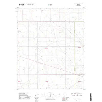
2020 Map of El Morro Ranch
USGS Topo · Published 2020About this map
El Morro Ranch sits at the northern edge of this high-desert landscape, where ranching operations are supported by local access along Co Rd 3f. The terrain is defined by the ephemeral flow of Salado Cr and the distinct landform of Sotano Blanco in the western reaches of the quadrangle. This area of eastern New Mexico remains largely rural and sparsely populated, with a survey grid that reflects the administrative divide between Guadalupe and De Baca counties. The map documents the presence of Co Rd 3h as it crosses the lower plains, providing a modern perspective on the enduring cattle-ranching culture that has long characterized this region. Its topographic details reveal the subtle drainage patterns and landforms that dictate movement and settlement in this arid environment.
Find a feature on this map
14 named features on this map. Tap any name to fly to it.
Don’t see what you’re looking for? This feature index may not catch every label — zoom into the map to look around manually.
Map Details
Editions of this 2020 El Morro Ranch Map
This is the sole edition of this map. No revisions or reprints were ever made.
Other maps of this area

1954 · Fort Sumner
USGS Topo · 1:250,000

1958 · Fort Sumner
USGS Topo · 1:250,000

1978 · El Morro Ranch SE
USGS Topo · 1:24,000

1978 · El Morro Ranch
USGS Topo · 1:24,000

1978 · Laguna De Los Terreros
USGS Topo · 1:24,000

1978 · El Morro Ranch NW
USGS Topo · 1:24,000

1978 · Long Draw
USGS Topo · 1:24,000
1978 · Burro Lake
USGS Topo · 1:24,000

1979 · Fort Sumner
USGS Topo · 1:100,000

1980 · Corona
USGS Topo · 1:100,000