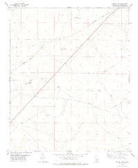
1978 Map of Burro Lake
USGS Topo · Published 1979About this map
Burro Lake serves as a focal point in this high-plains landscape of Guadalupe County, where water sources dictate the placement of human infrastructure. The arid environment is defined by intermittent drainage systems like San Pablo Draw and the critical presence of named water stations and livestock infrastructure. Ranching history is evident through the distribution of family-named landmarks such as North Winkle Windmill, Winkle Windmill, and the Block Windmill. The Southern Pacific railroad cuts a straight diagonal across the northern terrain, marking the primary industrial corridor through this sparsely populated region. These topographic details reveal how life and transit in the late 1970s relied heavily on the reliable placement of wells like Twin Wells and the San Pablo Windmill to sustain agriculture and travel.
Find a feature on this map
8 named features on this map. Tap any name to fly to it.
Don’t see what you’re looking for? This feature index may not catch every label — zoom into the map to look around manually.
Map Details
Editions of this 1978 Burro Lake Map
This is the sole edition of this map. No revisions or reprints were ever made.
Other maps of this area

1954 · Fort Sumner
USGS Topo · 1:250,000

1958 · Fort Sumner
USGS Topo · 1:250,000
1978 · George Ranch
USGS Topo · 1:24,000

1978 · Mesa Leon
USGS Topo · 1:24,000
1978 · Tapia Ranch
USGS Topo · 1:24,000

1978 · Vaughn
USGS Topo · 1:24,000

1978 · El Morro Ranch
USGS Topo · 1:24,000
1978 · Pastura
USGS Topo · 1:24,000

1978 · El Morro Ranch NW
USGS Topo · 1:24,000

1978 · Long Draw
USGS Topo · 1:24,000