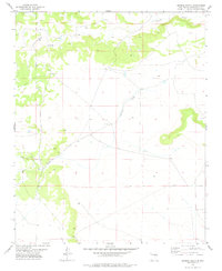
1978 Map of George Ranch
USGS Topo · Published 1978About this map
George Ranch and Roark Ranch anchor this high-plains landscape in Guadalupe County during the late 1970s. The map reveals a specialized cattle-ranching environment where the survival of the operation depends on the ephemeral waters of Arroyo Pintada and the drainage of Leoncito Draw. The presence of several scattered Tanks and a Well across the sections highlights the critical infrastructure required for livestock management in this arid portion of New Mexico. The terrain is marked by distinct mesas and canyon rims, with the underlying survey grid providing the framework for land ownership and grazing boundaries between the townships.
Find a feature on this map
11 named features on this map. Tap any name to fly to it.
Don’t see what you’re looking for? This feature index may not catch every label — zoom into the map to look around manually.
Map Details
Editions of this 1978 George Ranch Map
This is the sole edition of this map. No revisions or reprints were ever made.
Other maps of this area

1954 · Fort Sumner
USGS Topo · 1:250,000

1958 · Fort Sumner
USGS Topo · 1:250,000
1978 · Milagro Spring
USGS Topo · 1:24,000

1978 · Mesa Leon
USGS Topo · 1:24,000
1978 · Tapia Ranch
USGS Topo · 1:24,000
1978 · Pintada
USGS Topo · 1:24,000

1978 · Santa Barbara Lake
USGS Topo · 1:24,000
1978 · Milagro
USGS Topo · 1:24,000
1978 · Pinavete Canyon
USGS Topo · 1:24,000
1978 · Burro Lake
USGS Topo · 1:24,000