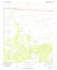
1978 Map of Milagro
USGS Topo · Published 1978About this map
Milagro stands as the primary settlement in this part of Guadalupe County, situated at a crossroad of high-desert drainage systems and mid-century transportation routes. The landscape is defined by the sharp incisions of Milagro Canyon and the broad reach of Encinosa Draw, which cut through the high plains toward the Anton Chico grant lands. These natural features dictated the placement of early infrastructure, most notably the dual alignment of Interstate 40 and the older Route 66 corridor crossing the northern sections. In the southern reaches, the presence of the Sombrio Cem provides a poignant genealogical anchor, marking the site of a community tied to the land well before the modern highway era. The map detail highlights how the terrain of Canon de Baca influenced the path of local ranch roads and territorial boundaries during the late 1970s.
Find a feature on this map
12 named features on this map. Tap any name to fly to it.
Don’t see what you’re looking for? This feature index may not catch every label — zoom into the map to look around manually.
Map Details
Editions of this 1978 Milagro Map
This is the sole edition of this map. No revisions or reprints were ever made.
Other maps of this area

1890 · Bernal
USGS Topo · 1:125,000

1891 · Bernal
USGS Topo · 1:125,000

1894 · Bernal
USGS Topo · 1:125,000

1954 · Santa Fe
USGS Topo · 1:250,000

1954 · Fort Sumner
USGS Topo · 1:250,000

1958 · Fort Sumner
USGS Topo · 1:250,000

1958 · Santa Fe
USGS Topo · 1:250,000
1963 · Thompson Ranch
USGS Topo · 1:24,000
1963 · Mesa Palo Amarillo
USGS Topo · 1:24,000
1963 · Potrillo Hill
USGS Topo · 1:24,000