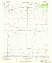
1960 Map of El Nido
USGS Topo · Published 1961About this map
El Nido and the settlement of Lingard anchor this 1960 topographical study of Merced County, where an intricate network of irrigation laterals and sloughs defines the agricultural landscape. The Southern Pacific railroad cuts a sharp diagonal through the northeast, passing through Lingard and alongside Snake Slough. The region's hydrologic character is evident in the meandering paths of Mariposa Creek, Deadman Creek, and Dutchman Creek, which traverse the alluvial plain toward the El Nido Reservoir. Local recreation and land use are noted through the presence of the Duck Club and associated Duck Ponds in the central-western portion of the map. This era shows the transition of the Central Valley into a highly managed hydraulic environment, with family-named routes such as McNamara Road and Russell Road providing the primary grid for the expanding farmsteads between the creek beds.
Find a feature on this map
27 named features on this map. Tap any name to fly to it.
Don’t see what you’re looking for? This feature index may not catch every label — zoom into the map to look around manually.
Map Details
Editions of this 1960 El Nido Map
2 editions found
Other maps of this area

1914 · Merced
USGS Topo · 1:31,680

1916 · Santa Rita Bridge
USGS Topo · 1:24,000

1917 · Merced
USGS Topo · 1:31,680

1918 · Bliss Ranch
USGS Topo · 1:31,680

1918 · Lingard
USGS Topo · 1:31,680

1918 · Atwater
USGS Topo · 1:31,680

1918 · Chowchilla
USGS Topo · 1:31,680

1918 · Sandy Mush
USGS Topo · 1:31,680

1918 · Planada
USGS Topo · 1:31,680

1919 · Plainsberg
USGS Topo · 1:31,680