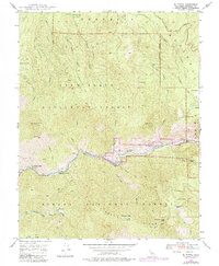
1947 Map of El Portal
USGS Topo · Published 1984About this map
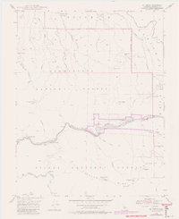
The Merced River serves as the central artery for this 1947 study, cutting through the canyon where the boundaries of Yosemite National Park, Stanislaus National Forest, and Sierra National Forest converge. The settlement of El Portal is clearly mapped along the riverbanks, serving as a gateway community just west of the park entrance. Historical transportation routes are prominent, including the Yosemite All-Year Highway and the Old Coulterville Road, which negotiate the steep terrain of the canyon walls.
Find a feature on this map
46 named features on this map. Tap any name to fly to it.
Don’t see what you’re looking for? This feature index may not catch every label — zoom into the map to look around manually.
Map Details
Editions of this 1947 El Portal Map
6 editions found
Other maps of this area

1897 · Yosemite
USGS Topo · 1:125,000

1900 · Yosemite
USGS Topo · 1:125,000

1903 · Yosemite
USGS Topo · 1:125,000

1909 · Yosemite
USGS Topo · 1:125,000

1947 · El Portal
USGS Topo · 1:24,000

1947 · Mariposa
USGS Topo · 1:250,000

1947 · El Portal
USGS Topo · 1:62,500

1947 · Buckingham Mtn
USGS Topo · 1:24,000
1947 · Feliciana Mtn.
USGS Topo · 1:24,000
1947 · Kinsley
USGS Topo · 1:24,000