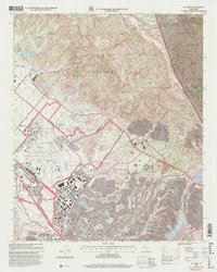
1997 Map of El Toro
USGS Topo · Published 2000About this map
The El Toro Marine Corps Air Station dominates this late-twentieth-century landscape, showing a dense network of runways, communication beacons, and military housing just before the facility's official decommissioning. This era captures the transition of the Lomas de Santiago foothills from an agricultural and ranching interior to a rapidly expanding suburban corridor. While the San Diego Freeway and Alton Parkway represent the modern transit infrastructure, older local sites like the Heritage Hill Historical Park and the El Toro Cem preserve the region's earlier heritage. Further inland, the map details the rugged boundary of the Cleveland National Forest, where the settlement of Modjeska and the Silverado Sch sit nestled among the canyons. This document provides a clear look at the intersection of defense industry, specialized agriculture at the South Coast Agriculture Field Station, and the residential growth of El Toro.
Find a feature on this map
45 named features on this map. Tap any name to fly to it.
Don’t see what you’re looking for? This feature index may not catch every label — zoom into the map to look around manually.
Map Details
Editions of this 1997 El Toro Map
This is the sole edition of this map. No revisions or reprints were ever made.
Other maps of this area

1896 · Santa Ana
USGS Topo · 1:62,500

1896 · Anaheim
USGS Topo · 1:62,500

1898 · Anaheim
USGS Topo · 1:62,500

1901 · Southern California Sheet No. 1
USGS Topo · 1:250,000

1901 · Santa Ana
USGS Topo · 1:62,500

1901 · Anaheim
USGS Topo · 1:62,500

1902 · Corona
USGS Topo · 1:125,000

1904 · Southern California Sheet No. 1
USGS Topo · 1:250,000

1932 · Orange
USGS Topo · 1:31,680

1932 · Tustin
USGS Topo · 1:31,680