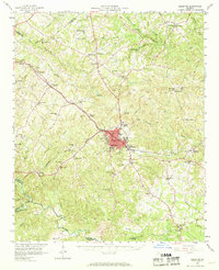
1958 Map of Elberton
USGS Topo · Published 1969About this map
Elberton serves as the industrial and transport hub of Elbert County in the late 1950s, defined by its extensive granite quarrying operations and the convergence of the Southern and Seaboard Air Line railroads. The town center is densely detailed, featuring landmark structures such as the Silk Mills, a Hospital, and the Radio Tower (WSGC). Surrounding the municipality, numerous rural communities like Hard Cash, Dewy Rose, and Fortsonia are anchored by local institutions including Stinchcomb School and Liberty Church.
Find a feature on this map
81 named features on this map. Tap any name to fly to it.
Don’t see what you’re looking for? This feature index may not catch every label — zoom into the map to look around manually.
Map Details
Editions of this 1958 Elberton Map
2 editions found
Other maps of this area

1891 · Carnesville
USGS Topo · 1:125,000

1893 · Elberton
USGS Topo · 1:125,000

1906 · Crawfordville
USGS Topo · 1:125,000

1953 · Athens
USGS Topo · 1:250,000

1954 · Greenville
USGS Topo · 1:250,000

1955 · Broad
USGS Topo · 1:24,000

1958 · Greenville
USGS Topo · 1:250,000

1958 · Athens
USGS Topo · 1:250,000

1958 · Danielsville
USGS Topo · 1:62,500

1958 · Elberton
USGS Topo · 1:62,500