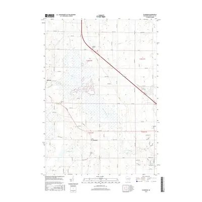
2015 Map of Eldorado
USGS Topo · Published 2015About this map
Eldorado Marsh dominates the central landscape of this Fond du Lac County region, serving as a significant hydrologic hub where the West Branch Fond Du Lac River meanders through protected wetlands. This 2015 survey illustrates a rural Wisconsin environment defined by agricultural section lines and a high concentration of small, family-linked burial grounds. Genealogists will find several distinct sites including the Methodist Episcopal Cem, Anderson Cem, and the North Lamartine Cem near Woodhull. The settlement of Eldorado sits at the western edge, while smaller watercourses like Van Dyne Cr and Sevenmile Cr drain the surrounding fields. The road network, including Co Rd OOO and Rogersville Rd, traces the historic land divisions that have organized this farming community for generations.
Find a feature on this map
79 named features on this map. Tap any name to fly to it.
Don’t see what you’re looking for? This feature index may not catch every label — zoom into the map to look around manually.
Map Details
Editions of this 2015 Eldorado Map
This is the sole edition of this map. No revisions or reprints were ever made.
Other maps of this area

1910 · Fond du Lac
USGS Topo · 1:62,500

1955 · Waupun
USGS Topo · 1:62,500

1955 · Campbellsport
USGS Topo · 1:62,500

1955 · Fond Du Lac
USGS Topo · 1:62,500

1955 · Fond Du Lac
USGS Topo · 1:24,000

1956 · Rosendale
USGS Topo · 1:62,500

1957 · Madison
USGS Topo · 1:250,000

1960 · Madison
USGS Topo · 1:250,000
1974 · Fahrney Point
USGS Topo · 1:24,000
1974 · Byron
USGS Topo · 1:24,000