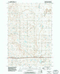
1990 Map of Eldridge NW
USGS Topo · Published 1995About this map
National Waterfowl Production Area lands dominate the southeastern corner of this Stutsman County landscape, signifying the region's importance to the prairie pothole ecosystem. This 1990 revision, based on surveys dating back to 1948 and 1951, reveals a terrain defined by glacial depressions and intermittent water bodies. Notable basins such as Deer Lake in the north and the expansive Moon Lake to the south are connected by the meandering Minneapolis Creek, which flows through the Flats. The map detail includes a local Gravel Pit near Lippert and the waters of Adkinson Lake, illustrating a rural environment where land use is tied closely to the natural hydrology of central North Dakota. Names like Windsor and Hidden mark the township divisions of this agricultural and conservation-focused territory.
Find a feature on this map
11 named features on this map. Tap any name to fly to it.
Don’t see what you’re looking for? This feature index may not catch every label — zoom into the map to look around manually.
Map Details
Editions of this 1990 Eldridge NW Map
This is the sole edition of this map. No revisions or reprints were ever made.
Other maps of this area

1896 · Jamestown
USGS Topo · 1:125,000

1900 · Pingree
USGS Topo · 1:125,000

1900 · Pingree
USGS Topo · 1:62,500

1950 · Buchanan
USGS Topo · 1:24,000

1951 · Eldridge SE
USGS Topo · 1:24,000

1951 · Eldridge NW
USGS Topo · 1:24,000

1952 · Buchanan
USGS Topo · 1:24,000

1952 · Eldridge
USGS Topo · 1:24,000

1952 · Pingree SW
USGS Topo · 1:24,000

1952 · Eldridge SW
USGS Topo · 1:24,000