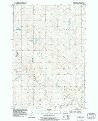
1990 Map of Eldridge SE
USGS Topo · Published 1995About this map
Beaver Creek meanders through this portion of Stutsman County, carving a low-lying path across a landscape defined by glacial prairie potholes and wetland conservation. The terrain is structured by the townships of Lippert, Woodbury, Lenton, and Sydney, where the Public Land Survey System creates a rigid grid of sections against the organic shapes of the water. Extensive tracts of the National Waterfowl Production Area are preserved here, highlighting the region's importance within the Central Flyway. This map, based on surveys dating back to the mid-20th century but revised with 1990 imagery, captures the intersection of intensive agricultural sectioning and the deliberate protection of native prairie wetlands. The absence of major settlements emphasizes the rural, conservation-focused character of the plains south of Eldridge.
Find a feature on this map
9 named features on this map. Tap any name to fly to it.
Don’t see what you’re looking for? This feature index may not catch every label — zoom into the map to look around manually.
Map Details
Editions of this 1990 Eldridge SE Map
This is the sole edition of this map. No revisions or reprints were ever made.
Other maps of this area

1896 · Jamestown
USGS Topo · 1:125,000

1951 · Jamestown
USGS Topo · 1:24,000

1951 · Eldridge SE
USGS Topo · 1:24,000

1951 · Eldridge NW
USGS Topo · 1:24,000

1952 · Eldridge
USGS Topo · 1:24,000

1952 · Homer
USGS Topo · 1:24,000

1952 · Jud NW
USGS Topo · 1:24,000

1952 · Eldridge SW
USGS Topo · 1:24,000

1953 · Jamestown
USGS Topo · 1:250,000

1953 · Montpelier NW
USGS Topo · 1:24,000