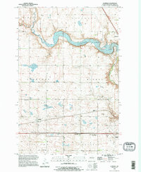
1990 Map of Eldridge
USGS Topo · Published 1995About this map
Eldridge sits at the heart of this prairie landscape, reflecting the rural character of Stutsman County in the 1990s. The town's local history is anchored by the Eldridge Cem and the passing tracks of the Minneapolis St Paul and Sault Ste Marie RR. The northern portion of the map is dominated by the sprawling waters of Pipestem Lake, which drastically altered the drainage patterns of the region's townships. Moving south, the modern infrastructure of Interstate 94 is evidenced by Interchange 251 and established Rest Areas. The map's detail preserves a record of land use across multiple townships, from Hidden and Buchanan in the north to Lippert and Woodbury in the south, including the transition toward the Jamestown Corp Bdy at the eastern edge. A prominent Comm Tower stands near the lake, serving as a modern landmark among the section lines.
Find a feature on this map
15 named features on this map. Tap any name to fly to it.
Don’t see what you’re looking for? This feature index may not catch every label — zoom into the map to look around manually.
Map Details
Editions of this 1990 Eldridge Map
This is the sole edition of this map. No revisions or reprints were ever made.
Other maps of this area

1896 · Jamestown
USGS Topo · 1:125,000

1900 · Pingree
USGS Topo · 1:125,000

1900 · Pingree
USGS Topo · 1:62,500

1950 · Buchanan
USGS Topo · 1:24,000

1950 · Fried
USGS Topo · 1:24,000

1951 · Jamestown
USGS Topo · 1:24,000

1951 · Fried
USGS Topo · 1:24,000

1951 · Eldridge SE
USGS Topo · 1:24,000

1951 · Eldridge NW
USGS Topo · 1:24,000

1952 · Buchanan
USGS Topo · 1:24,000