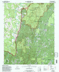
1994 Map of Eleazer
USGS Topo · Published 1996About this map
The Uwharrie River winds through the western reaches of this 1994 survey, defining a landscape dominated by the protected forests of the Uwharrie National Forest. The map documents a rural corridor along the border of Randolph and Montgomery counties, anchored by the small settlements of Eleazer and Abner. This area is characterized by significant topographic relief, including the Birkhead Mountains Wilderness where peaks like Coolers Knob Mountain and Talberts Mountain rise above the drainage basins of Hannahs Creek and Birkhead Creek. Social and community hubs are visible through several country churches, such as Oak Grove Ch and Mt Lebanon Ch. The landscape remains largely undeveloped, preserved for conservation and recreation, with numerous stream branches such as Robbins Branch feeding into the Little River and Springs Lake to the south.
Find a feature on this map
36 named features on this map. Tap any name to fly to it.
Don’t see what you’re looking for? This feature index may not catch every label — zoom into the map to look around manually.
Map Details
Editions of this 1994 Eleazer Map
This is the sole edition of this map. No revisions or reprints were ever made.
Other maps of this area

1942 · Troy
USGS Topo · 1:125,000

1953 · Raleigh
USGS Topo · 1:250,000

1953 · Charlotte
USGS Topo · 1:250,000

1954 · Charlotte
USGS Topo · 1:250,000

1954 · Raleigh
USGS Topo · 1:250,000

1957 · Albemarle
USGS Topo · 1:62,500

1957 · Denton
USGS Topo · 1:62,500

1957 · Troy
USGS Topo · 1:62,500

1957 · Asheboro
USGS Topo · 1:62,500

1960 · Charlotte
USGS Topo · 1:250,000