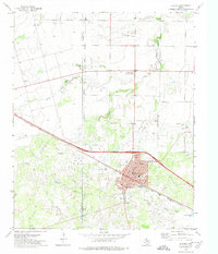
1972 Map of Electra
USGS Topo · Published 1974About this map
Electra and its sprawling oil fields dominate the landscape of the Red River valley borderlands in the early 1970s. The town's grid is dense with community infrastructure, including the High Sch, Ward Sch, and a dedicated Rodeo Ground on the southern edge. The industrial footprint of the region is evident through a extensive network of Oil Wells, a Gasoline Plant, and a massive Pipeline cutting across the terrain.
Find a feature on this map
26 named features on this map. Tap any name to fly to it.
Don’t see what you’re looking for? This feature index may not catch every label — zoom into the map to look around manually.
Map Details
Editions of this 1972 Electra Map
This is the sole edition of this map. No revisions or reprints were ever made.
Other maps of this area

1915 · Barwise School
USGS Topo · 1:24,000

1916 · Electra
USGS Topo · 1:24,000

1916 · Fowlkes
USGS Topo · 1:24,000

1917 · Beaver Creek
USGS Topo · 1:24,000

1918 · Electra
USGS Topo · 1:31,680

1918 · Barwise School
USGS Topo · 1:31,680

1919 · Fowlkes
USGS Topo · 1:31,680

1920 · Beaver Creek
USGS Topo · 1:31,680

1954 · Wichita Falls
USGS Topo · 1:250,000

1955 · Lawton
USGS Topo · 1:250,000