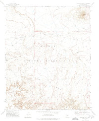
1972 Map of Elephant Butte
USGS Topo · Published 1974About this map
Ives Mesa dominates the southern landscape of this high-desert region, situated entirely within the Navajo Indian Reservation. This 1972 field-checked survey reveals a territory defined by complex drainage systems and significant geological formations. The eponymous Elephant Butte rises in the northeast corner, serving as a primary landmark for the surrounding plateau. Water management and resource transport are the primary human markers on the land, evidenced by a Well located along Bird Springs Wash and a prominent Pipeline that traverses the northern sections. The map traces the winding paths of Coyote Wash and Johns Draw, illustrating how seasonal water flow has carved the mesas and canyons over time. This document provides a clear look at the spatial relationship between traditional lands and modern utility infrastructure in this portion of the Arizona-Navajo county borderlands during the early 1970s.
Find a feature on this map
12 named features on this map. Tap any name to fly to it.
Don’t see what you’re looking for? This feature index may not catch every label — zoom into the map to look around manually.
Map Details
Editions of this 1972 Elephant Butte Map
This is the sole edition of this map. No revisions or reprints were ever made.
Other maps of this area

1883 · Tusayan
USGS Topo · 1:250,000

1886 · Tusayan
USGS Topo · 1:250,000

1947 · Flagstaff
USGS Topo · 1:250,000

1954 · Winslow
USGS Topo · 1:62,500

1954 · Winslow 4 NW
USGS Topo · 1:24,000

1954 · Winslow 4 NE
USGS Topo · 1:24,000

1954 · Flagstaff
USGS Topo · 1:250,000

1957 · Winslow 1 SW
USGS Topo · 1:24,000

1958 · Flagstaff
USGS Topo · 1:250,000

1960 · Flagstaff
USGS Topo · 1:250,000