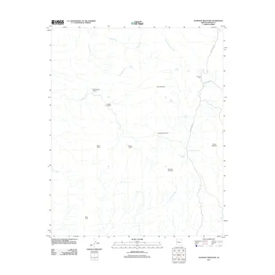
2011 Map of Elephant Mountain
USGS Topo · Published 2011About this map
Elephant Mountain and Grey Mountain dominate the skyline of this Mohave County landscape, where water sources dictate the movement of people and livestock. This 2011 survey reveals a network of vital desert water points including Arrowweed Springs, Hobo Spring, and Arrowhead Spring, many of which sit tucked into the complex drainage systems of Chalk Spring Canyon and Arrowweed Canyon. The presence of Sycamore Camp along the eastern edge, near the confluence of Sycamore Creek and Chollo Ranch RD, suggests the area's continued use for ranching or seasonal backcountry access. From the heights of Neale Mesa to the dramatic drop of Burro Cliffs, the map traces the intricate hydrology of the region, where seasonal flows like Box Canyon Wash and Gray Wash carve through the basin and range terrain.
Find a feature on this map
28 named features on this map. Tap any name to fly to it.
Don’t see what you’re looking for? This feature index may not catch every label — zoom into the map to look around manually.
Map Details
Editions of this 2011 Elephant Mountain Map
This is the sole edition of this map. No revisions or reprints were ever made.
Other maps of this area

1923 · Signal
USGS Topo · 1:250,000

1942 · Signal
USGS Topo · 1:250,000

1950 · Prescott
USGS Topo · 1:250,000

1954 · Prescott
USGS Topo · 1:250,000

1958 · Prescott
USGS Topo · 1:250,000

1959 · Prescott
USGS Topo · 1:250,000

1960 · Prescott
USGS Topo · 1:250,000

1965 · Prescott
USGS Topo · 1:250,000
1967 · Tule Wash
USGS Topo · 1:24,000
1967 · Greenwood Peak
USGS Topo · 1:24,000