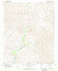
1967 Map of Greenwood Peak
USGS Topo · Published 1970About this map
The Big Sandy River and Burro Creek converge in this arid section of Mohave County, where the desert landscape is defined by the high elevations of the Poachie Range. By the late 1960s, the map indicates the former location of a community at Greenwood (Site), situated near a Ford on the riverbank. This area preserves a history of ranching and early infrastructure, featuring family-held lands such as Madril Ranch, Rohr Ranch, and Leivas Ranch.
Find a feature on this map
16 named features on this map. Tap any name to fly to it.
Don’t see what you’re looking for? This feature index may not catch every label — zoom into the map to look around manually.
Map Details
Editions of this 1967 Greenwood Peak Map
2 editions found
Other maps of this area

1923 · Signal
USGS Topo · 1:250,000

1942 · Signal
USGS Topo · 1:250,000

1950 · Prescott
USGS Topo · 1:250,000

1954 · Prescott
USGS Topo · 1:250,000

1958 · Prescott
USGS Topo · 1:250,000

1959 · Prescott
USGS Topo · 1:250,000

1960 · Prescott
USGS Topo · 1:250,000

1965 · Prescott
USGS Topo · 1:250,000

1966 · Artillery Peak
USGS Topo · 1:62,500
1967 · Groom Spring
USGS Topo · 1:24,000