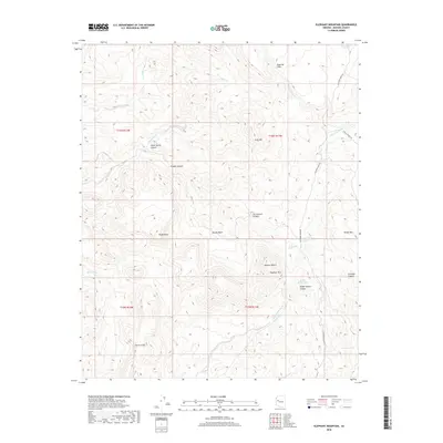
2018 Map of Elephant Mountain
USGS Topo · Published 2018About this map
Elephant Mtn dominates the central landscape of this Mohave County quadrangle, situated within the northern reaches of the Mojave Desert. The topography is defined by significant vertical relief, ranging from the sheer Aquarius Cliffs in the northeast to the Burro Cliffs in the southwest. A network of ephemeral drainages, including Bitter Creek and the multiple branches of Sycamore Creek, carve deep into the plateau. This 2018 survey reveals a territory primarily defined by its landforms rather than human settlements, where access is limited to a few unpaved routes like Sycamore Creek Rd. The presence of water sources such as Arrowweed Springs and livestock infrastructure like Slaughter Tank and Dead Cow Tank point to the area's utility for ranching amidst the canyons of Brushy Basin and Cornwall Canyon.
Find a feature on this map
32 named features on this map. Tap any name to fly to it.
Don’t see what you’re looking for? This feature index may not catch every label — zoom into the map to look around manually.
Map Details
Editions of this 2018 Elephant Mountain Map
This is the sole edition of this map. No revisions or reprints were ever made.
Other maps of this area

1923 · Signal
USGS Topo · 1:250,000

1942 · Signal
USGS Topo · 1:250,000

1950 · Prescott
USGS Topo · 1:250,000

1954 · Prescott
USGS Topo · 1:250,000

1958 · Prescott
USGS Topo · 1:250,000

1959 · Prescott
USGS Topo · 1:250,000

1960 · Prescott
USGS Topo · 1:250,000

1965 · Prescott
USGS Topo · 1:250,000
1967 · Tule Wash
USGS Topo · 1:24,000
1967 · Greenwood Peak
USGS Topo · 1:24,000