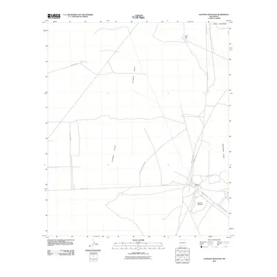
2010 Map of Elephant Mountain
USGS Topo · Published 2010About this map
Elephant Mountain and the surrounding high desert of the Tularosa Valley dominate this landscape within the boundaries of the White Sands Missile Range. The area is characterized by isolated outposts and specialized military infrastructure, notably the Orogrande Range Camp and McNew West Camp. These sites are linked by a network of restricted access roads such as WSMR P Route 2 and WSMR S Route 251. To the east, the Jarilla Mountains rise abruptly from the valley floor, providing a topographical boundary to the sprawling government range. The presence of the Oregrande Range Camp Rd suggests the logistical importance of this sector in supporting operations within the missile range. This 2010 survey documents a modern chapter of New Mexico's military history, focusing on the infrastructure necessary for high-desert training and testing during the early 21st century.
Find a feature on this map
11 named features on this map. Tap any name to fly to it.
Don’t see what you’re looking for? This feature index may not catch every label — zoom into the map to look around manually.
Map Details
Editions of this 2010 Elephant Mountain Map
This is the sole edition of this map. No revisions or reprints were ever made.
Other maps of this area

1916 · Point Of Sands
USGS Topo · 1:125,000

1940 · Orogrande
USGS Topo · 1:62,500

1943 · Parker Lake
USGS Topo · 1:62,500

1943 · Orogrande
USGS Topo · 1:62,500

1947 · Orogrande North
USGS Topo · 1:24,000

1947 · Lake Lucero
USGS Topo · 1:62,500

1948 · El Wood
USGS Topo · 1:24,000
1948 · Orogrande South
USGS Topo · 1:24,000
1948 · Parker Lake SE
USGS Topo · 1:24,000

1948 · Elephant Mountain
USGS Topo · 1:24,000