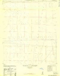
1948 Map of Parker Lake SE
USGS Topo · Published 1948About this map
The Fort Bliss Military Reservation dominates this 1948 topographic study of the Tularosa Valley floor. Compiled by the Army Map Service and later released for civil use by the U.S. Geological Survey, the map provides a look at the expansive desert landscape during the early post-war era. The terrain is marked by subtle elevation changes and natural depressions, organized by a strict grid of public land survey lines including T 22 S, T 23 S, and T 24 S. Unlike populated regions, this area is defined by its military use and lack of permanent civilian settlements, showing a network of unimproved dirt roads and trails that served the sprawling reservation before the height of the Cold War expansion.
Find a feature on this map
7 named features on this map. Tap any name to fly to it.
Don’t see what you’re looking for? This feature index may not catch every label — zoom into the map to look around manually.
Map Details
Editions of this 1948 Parker Lake SE Map
This is the sole edition of this map. No revisions or reprints were ever made.
Other maps of this area

1940 · Orogrande
USGS Topo · 1:62,500

1940 · Newman
USGS Topo · 1:62,500

1941 · Desert
USGS Topo · 1:62,500

1943 · Parker Lake
USGS Topo · 1:62,500

1943 · Desert
USGS Topo · 1:62,500

1943 · Newman
USGS Topo · 1:62,500

1943 · Orogrande
USGS Topo · 1:62,500

1948 · Davies Tank
USGS Topo · 1:24,000

1948 · El Wood
USGS Topo · 1:24,000

1948 · Newman NW
USGS Topo · 1:24,000