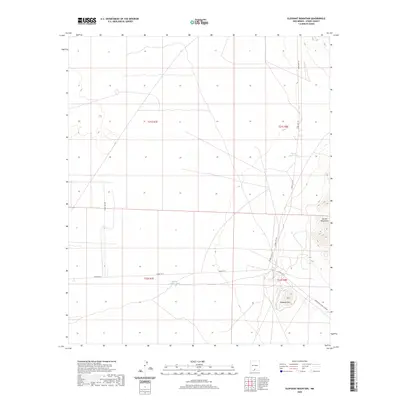
2020 Map of Elephant Mountain
USGS Topo · Published 2020About this map
Elephant Mtn rises above the arid plains of the Tularosa Basin, serving as a prominent landmark in this desert corridor of southern New Mexico. The landscape is defined by the western slopes of the Jarilla Mountains and a sparse network of water sources essential for cattle or wildlife, including Flying Eagle Tank and McNew Feeder Tank. This area is heavily influenced by military infrastructure, as evidenced by the series of White Sands Missile Range roads such as WSMR P Rt 2 and WSMR S Rt 252 that crisscross the basin. The map illustrates the specialized use of this high-desert terrain, where limited ranching features like tanks exist alongside the transit routes serving the Oregrande Range Camp Rd and restricted government zones.
Find a feature on this map
12 named features on this map. Tap any name to fly to it.
Don’t see what you’re looking for? This feature index may not catch every label — zoom into the map to look around manually.
Map Details
Editions of this 2020 Elephant Mountain Map
This is the sole edition of this map. No revisions or reprints were ever made.
Other maps of this area

1916 · Point Of Sands
USGS Topo · 1:125,000

1940 · Orogrande
USGS Topo · 1:62,500

1943 · Parker Lake
USGS Topo · 1:62,500

1943 · Orogrande
USGS Topo · 1:62,500

1947 · Orogrande North
USGS Topo · 1:24,000

1947 · Lake Lucero
USGS Topo · 1:62,500

1948 · El Wood
USGS Topo · 1:24,000
1948 · Orogrande South
USGS Topo · 1:24,000
1948 · Parker Lake SE
USGS Topo · 1:24,000

1948 · Elephant Mountain
USGS Topo · 1:24,000