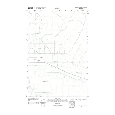
2011 Map of Elephant Mountain
USGS Topo · Published 2011About this map
Artesian and the high peaks of the Rattlesnake Hills anchor this portion of Yakima County. The landscape is defined by the significant rise of Elephant Mountain and the deep incisions of Kittitas Canyon and Washout Gulch, showcasing the transition from valley floor to upland ridge. Family-named roads like Beane Rd, Postma Rd, and Desmarais Rd grid the agricultural lands, reflecting the long-term settlement patterns of the region. Local history is centered around the Holy Rosary Cemetery and the residential cluster at Rocky Acres in the northwest. Water resources are scarce in this high desert terrain, marked only by isolated points like Coyote Spring, which traditionally served as vital landmarks for early settlers and ranchers in this part of Washington.
Find a feature on this map
40 named features on this map. Tap any name to fly to it.
Don’t see what you’re looking for? This feature index may not catch every label — zoom into the map to look around manually.
Map Details
Editions of this 2011 Elephant Mountain Map
This is the sole edition of this map. No revisions or reprints were ever made.
Other maps of this area

1910 · Zillah
USGS Topo · 1:125,000

1936 · Yakima East
USGS Topo · 1:48,000

1936 · Hog Ranch Buttes
USGS Topo · 1:48,000

1941 · Black Rock Spring
USGS Topo · 1:62,500

1941 · Yakima East
USGS Topo · 1:62,500

1950 · Yakima
USGS Topo · 1:250,000
1953 · Black Rock Spring NW
USGS Topo · 1:24,000

1953 · Pomona
USGS Topo · 1:24,000
1953 · Black Rock Spring SW
USGS Topo · 1:24,000

1953 · Elephant Mountain
USGS Topo · 1:24,000