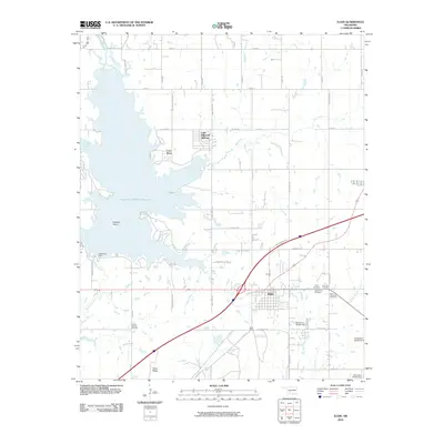
2010 Map of Elgin
USGS Topo · Published 2010About this map
Elgin serves as the focal point of this 2010 landscape, situated at the intersection of a developing road network in Comanche County. The area is defined by the massive Oknoname 031016 Reservoir, where Treasure Island sits near the western shore and residential developments like Lake Ellsworth Addition and Cove Acres suggest growing recreational interest along the water. The reservoir is contained by the Ellsworth Dam at its southern end, where East Cache Creek continues its course through the valley.
Find a feature on this map
54 named features on this map. Tap any name to fly to it.
Don’t see what you’re looking for? This feature index may not catch every label — zoom into the map to look around manually.
Map Details
Editions of this 2010 Elgin Map
This is the sole edition of this map. No revisions or reprints were ever made.
Other maps of this area

1946 · Lawton
USGS Topo · 1:62,500

1949 · Arbuckle Hill
USGS Topo · 1:24,000

1949 · Cement
USGS Topo · 1:62,500

1949 · Elgin
USGS Topo · 1:24,000

1949 · Fort Sill
USGS Topo · 1:24,000

1949 · Nellie
USGS Topo · 1:62,500

1955 · Lawton
USGS Topo · 1:250,000

1956 · Sterling
USGS Topo · 1:24,000

1956 · Fletcher
USGS Topo · 1:24,000

1956 · Arbuckle Hill
USGS Topo · 1:24,000