
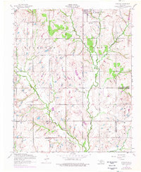
1956 Map of Sterling
USGS Topo · Published 1959About this map
Sterling serves as the primary hub of this landscape in the mid-1950s, located in a region where the undulating terrain of Richards Brown and Richland meets an active energy economy. The map reveals a dense network of petroleum infrastructure scattered across the countryside, specifically within the designated Oil Field. Numerous sites marked as Oil well and Oil slush tank are concentrated along the winding course of Ninemile Creek and the southern reaches of Beaver Creek, illustrating the intersection of natural drainage and industrial extraction.
Find a feature on this map
24 named features on this map. Tap any name to fly to it.
Don’t see what you’re looking for? This feature index may not catch every label — zoom into the map to look around manually.
Map Details
Editions of this 1956 Sterling Map
2 editions found
Other maps of this area

1946 · Lawton
USGS Topo · 1:62,500

1949 · Arbuckle Hill
USGS Topo · 1:24,000

1949 · Cement
USGS Topo · 1:62,500

1949 · Elgin
USGS Topo · 1:24,000

1949 · Nellie
USGS Topo · 1:62,500

1955 · Lawton
USGS Topo · 1:250,000

1956 · Ninemile Creek
USGS Topo · 1:24,000

1956 · Fletcher
USGS Topo · 1:24,000

1956 · Arbuckle Hill
USGS Topo · 1:24,000
1956 · Rocky Ford
USGS Topo · 1:24,000