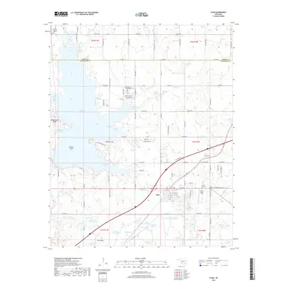
2018 Map of Elgin
USGS Topo · Published 2018About this map
Elgin serves as the primary hub of this Comanche County landscape, situated where local roads meet the arterial highway. The town is surrounded by several burial grounds, including Elgin Cem, Saint Anns Cem, and Elgin Memorial Cem, which provide significant points of interest for genealogical research. To the west, the sprawling waters of Lake Ellsworth dominate the topography, creating a jagged shoreline defined by numerous inlets such as Fulton Arm, Goodin Arm, and Hasenbach Arm.
Find a feature on this map
114 named features on this map. Tap any name to fly to it.
Don’t see what you’re looking for? This feature index may not catch every label — zoom into the map to look around manually.
Map Details
Editions of this 2018 Elgin Map
This is the sole edition of this map. No revisions or reprints were ever made.
Other maps of this area

1946 · Lawton
USGS Topo · 1:62,500

1949 · Arbuckle Hill
USGS Topo · 1:24,000

1949 · Cement
USGS Topo · 1:62,500

1949 · Elgin
USGS Topo · 1:24,000

1949 · Fort Sill
USGS Topo · 1:24,000

1949 · Nellie
USGS Topo · 1:62,500

1955 · Lawton
USGS Topo · 1:250,000

1956 · Sterling
USGS Topo · 1:24,000

1956 · Fletcher
USGS Topo · 1:24,000

1956 · Arbuckle Hill
USGS Topo · 1:24,000