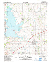
1991 Map of Elgin
USGS Topo · Published 1992About this map
Lake Ellsworth dominates the western portion of this 1991 survey, its irregular shoreline defined by numerous inlets such as Fulton Arm and Hasenback Arm. The expansion of residential lakeside communities is evident in the developments at Edgewater Park, Cove Acres, and the Lake Ellsworth Addition, which contrast with the older, established core of Elgin to the east. Along the southern border, the map details a significant portion of the Fort Sill Military Reservation, including the Frisco Ridge Airfield and a network of named ponds like Rudd Pond and O'Connell Pond. The local economy of the early 1990s is anchored by the H.E. Bailey Turnpike and marked by numerous Oil Wells and Gas Wells scattered across the landscape, while community heritage is preserved at St Ann Ch and the Elgin Community Cem.
Find a feature on this map
44 named features on this map. Tap any name to fly to it.
Don’t see what you’re looking for? This feature index may not catch every label — zoom into the map to look around manually.
Map Details
Editions of this 1991 Elgin Map
This is the sole edition of this map. No revisions or reprints were ever made.
Other maps of this area

1946 · Lawton
USGS Topo · 1:62,500

1949 · Arbuckle Hill
USGS Topo · 1:24,000

1949 · Cement
USGS Topo · 1:62,500

1949 · Elgin
USGS Topo · 1:24,000

1949 · Fort Sill
USGS Topo · 1:24,000

1949 · Nellie
USGS Topo · 1:62,500

1955 · Lawton
USGS Topo · 1:250,000

1956 · Sterling
USGS Topo · 1:24,000

1956 · Fletcher
USGS Topo · 1:24,000

1956 · Arbuckle Hill
USGS Topo · 1:24,000