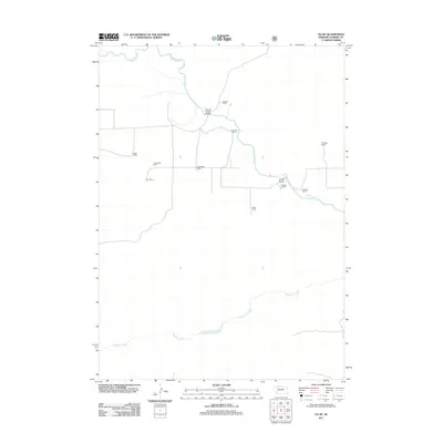
2011 Map of Eli SE
USGS Topo · Published 2011About this map
The Niobrara River winds through the northern portion of this Nebraska landscape, providing a vital water source for the numerous livestock operations scattered across the Sandhills. Ranching is the dominant land use, defined by family-named holdings such as Slocum Ranch, Robertson Ranch, and Heath Ranch. Transportation in this sparsely populated area is focused on river crossings, notably Boiling Spring Bridge and Mogle Bridge, which connect the disparate homesteads and pasturelands.
Find a feature on this map
14 named features on this map. Tap any name to fly to it.
Don’t see what you’re looking for? This feature index may not catch every label — zoom into the map to look around manually.
Map Details
Editions of this 2011 Eli SE Map
This is the sole edition of this map. No revisions or reprints were ever made.
Other maps of this area

1950 · Powderhorn Valley
USGS Topo · 1:62,500

1950 · Cody
USGS Topo · 1:62,500

1950 · Doughboy
USGS Topo · 1:62,500

1952 · Eli
USGS Topo · 1:62,500

1952 · Doughboy
USGS Topo · 1:62,500

1957 · Valentine
USGS Topo · 1:250,000

1959 · Valentine
USGS Topo · 1:250,000

1985 · Heath Valley
USGS Topo · 1:24,000

1985 · Eli SE
USGS Topo · 1:24,000
1985 · Cody East
USGS Topo · 1:24,000