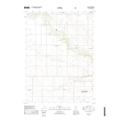
2017 Map of Eli SE
USGS Topo · Published 2017About this map
The Niobrara River winds through the northern reaches of this landscape, a critical water source for the surrounding Sandhills of Cherry County. This 2017 survey details the riparian corridor and its crossing points, specifically the Boiling Spring Bridge and Mogle Bridge, which provide essential connectivity in this sparsely settled region. To the south, the terrain transitions into the protected lands of the Samuel R McKelvie National Forest, an area characterized by its unique grassland ecology rather than traditional dense timber. The presence of Medicine Cr and the namesake Boiling Spring highlights the importance of groundwater and small tributaries in shaping the grazing and conservation patterns of the Nebraska interior. Local access is limited to a few named routes like Pryte Dr, reflecting the remote and quiet character of the area in the early 21st century.
Find a feature on this map
13 named features on this map. Tap any name to fly to it.
Don’t see what you’re looking for? This feature index may not catch every label — zoom into the map to look around manually.
Map Details
Editions of this 2017 Eli SE Map
This is the sole edition of this map. No revisions or reprints were ever made.
Other maps of this area

1950 · Powderhorn Valley
USGS Topo · 1:62,500

1950 · Cody
USGS Topo · 1:62,500

1950 · Doughboy
USGS Topo · 1:62,500

1952 · Eli
USGS Topo · 1:62,500

1952 · Doughboy
USGS Topo · 1:62,500

1957 · Valentine
USGS Topo · 1:250,000

1959 · Valentine
USGS Topo · 1:250,000

1985 · Heath Valley
USGS Topo · 1:24,000

1985 · Eli SE
USGS Topo · 1:24,000
1985 · Cody East
USGS Topo · 1:24,000