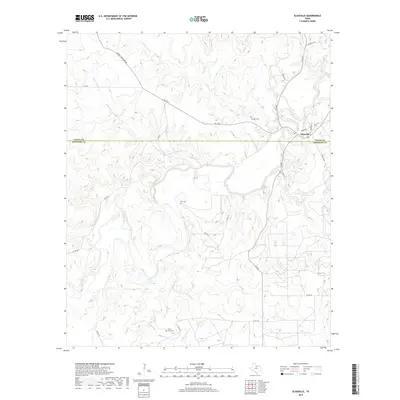
2019 Map of Eliasville
USGS Topo · Published 2019About this map
The settlement of Eliasville sits at the eastern edge of this landscape, situated near a prominent bend where Clear Fork meets Peach Cr. This region of North Texas is defined by its drainage network, with seasonal and perennial waterways like Wagon Timber Cr, Gage Cr, and Bufford Cr carving through the terrain. The map documents the boundary between Young and Stephens counties, illustrating how early settlement patterns and road systems like Murray Cemetary Rd and FM 1974 adapted to the local topography.
Find a feature on this map
29 named features on this map. Tap any name to fly to it.
Don’t see what you’re looking for? This feature index may not catch every label — zoom into the map to look around manually.
Map Details
Editions of this 2019 Eliasville Map
This is the sole edition of this map. No revisions or reprints were ever made.
Other maps of this area

1890 · Breckenridge
USGS Topo · 1:125,000

1925 · Graham 4-c
USGS Topo · 1:48,000

1925 · Breckenridge 1-b
USGS Topo · 1:48,000

1927 · Graham
USGS Topo · 1:62,500

1931 · Ivan
USGS Topo · 1:62,500

1954 · Abilene
USGS Topo · 1:250,000

1954 · Wichita Falls
USGS Topo · 1:250,000

1958 · Wichita Falls
USGS Topo · 1:250,000

1958 · Abilene
USGS Topo · 1:250,000

1958 · Breckenridge
USGS Topo · 1:24,000