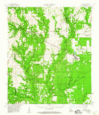
1959 Map of Elizabeth
USGS Topo · Published 1960About this map
Fullerton and Pitkin anchor the northwestern portion of this landscape, situated near the southern reaches of the Kisatchie National Forest. This survey captures a rural network of small timber-and-creek settlements connected by the Gulf Colorado and Santa Fe railroad, which cuts diagonally toward the town of Elizabeth. The area is notably dense with community centers, featuring a high concentration of country churches such as Occupy Ch No 1, Freedom Ch, and Arkadelphia Ch, alongside many family-named burial grounds including Tenmile Cem and Mathis Cem.
Find a feature on this map
68 named features on this map. Tap any name to fly to it.
Don’t see what you’re looking for? This feature index may not catch every label — zoom into the map to look around manually.
Map Details
Editions of this 1959 Elizabeth Map
2 editions found
Other maps of this area

1935 · Mittie
USGS Topo · 1:31,680

1935 · Pawnee
USGS Topo · 1:31,680

1935 · Oakdale
USGS Topo · 1:31,680

1941 · Slagle
USGS Topo · 1:62,500

1942 · Oakdale
USGS Topo · 1:62,500

1943 · Leander
USGS Topo · 1:62,500

1944 · Slagle
USGS Topo · 1:62,500

1947 · Foley
USGS Topo · 1:31,680

1947 · Steep Gully
USGS Topo · 1:31,680

1947 · Pine Chapel
USGS Topo · 1:31,680