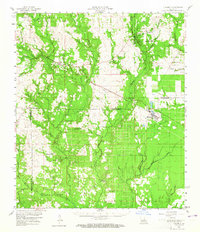
1959 Map of Elizabeth
USGS Topo · Published 1965About this map
Elizabeth and the surrounding pine-timbered lowlands of Allen Parish are defined by the convergence of industrial and rural life in the late 1950s. The Gulf Colorado and Santa Fe railroad serves as the primary corridor through the landscape, connecting the town of Pitkin with the smaller settlements of Dido and Fullerton. Much of the northern terrain is managed under the Kisatchie National Forest, where a network of watercourses including Sixmile Creek and Tenmile Creek provides natural drainage for the forest and local agricultural tracts. The map reveals a deeply rooted community infrastructure, evidenced by numerous rural houses of worship such as Arkadelphia Church and the uniquely named Occupy Church No 1 and Occupy Church No 2. Genealogists will find significant value in the documentation of family-named landmarks and resting places, such as the Mathis Cemetery and Hamilton Cemetery, which sit alongside the rural roads of the era.
Find a feature on this map
74 named features on this map. Tap any name to fly to it.
Don’t see what you’re looking for? This feature index may not catch every label — zoom into the map to look around manually.
Map Details
Editions of this 1959 Elizabeth Map
2 editions found
Other maps of this area

1935 · Mittie
USGS Topo · 1:31,680

1935 · Pawnee
USGS Topo · 1:31,680

1935 · Oakdale
USGS Topo · 1:31,680

1941 · Slagle
USGS Topo · 1:62,500

1942 · Oakdale
USGS Topo · 1:62,500

1943 · Leander
USGS Topo · 1:62,500

1944 · Slagle
USGS Topo · 1:62,500

1947 · Foley
USGS Topo · 1:31,680

1947 · Steep Gully
USGS Topo · 1:31,680

1947 · Pine Chapel
USGS Topo · 1:31,680