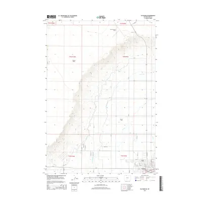
2015 Map of Elk Basin SE
USGS Topo · Published 2015About this map
The agricultural community of Powell anchors the southeastern corner of this survey, serving as a hub for the surrounding Big Horn Basin landscape. The town's layout is defined by its residential blocks and the presence of Northwest College, while the Powell Municipal Airport sits to the north. This region's development is deeply tied to its water management, evidenced by the extensive irrigation network including the Frannie Canal, Lateral A, Lateral B, and Lateral C. These systems draw water through the arid terrain to support the productive fields of Powell Flats. To the west, the land rises sharply toward the prominent landform of Polecat Bench, creating a distinct geographical boundary between the irrigated valley floor and the elevated northern plains. Small drainages like Bitter Creek traverse the southern portion of the map, illustrating the natural hydrology that local engineering has sought to harness.
Find a feature on this map
39 named features on this map. Tap any name to fly to it.
Don’t see what you’re looking for? This feature index may not catch every label — zoom into the map to look around manually.
Map Details
Editions of this 2015 Elk Basin SE Map
This is the sole edition of this map. No revisions or reprints were ever made.
Other maps of this area

1955 · Cody
USGS Topo · 1:250,000

1958 · Cody
USGS Topo · 1:250,000

1962 · Cody
USGS Topo · 1:250,000

1966 · Elk Basin SW
USGS Topo · 1:24,000

1966 · Garland
USGS Topo · 1:24,000

1966 · Elk Basin
USGS Topo · 1:24,000

1966 · Elk Basin NW
USGS Topo · 1:24,000

1966 · Deaver Reservoir
USGS Topo · 1:24,000

1966 · Elk Basin SE
USGS Topo · 1:24,000

1966 · Gilmore Hill NW
USGS Topo · 1:24,000