
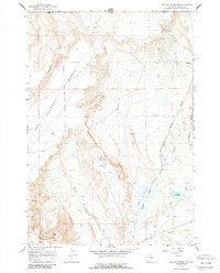
1966 Map of Deaver Reservoir
USGS Topo · Published 1969About this map
The borderlands of the Montana-Wyoming line are dominated by the extensive Polecat Bench, an elevated landform that overlooks an intricate system of energy and water infrastructure in the mid-1960s. The region is defined by the Chicago Burlington and Quincy railroad, which services the industrial activity of the Frannie Oil Field near the settlement of Frannie. This intersection of rail and petroleum resources underscores the mid-century industrial importance of northern Park County.
Find a feature on this map
22 named features on this map. Tap any name to fly to it.
Don’t see what you’re looking for? This feature index may not catch every label — zoom into the map to look around manually.
Map Details
Editions of this 1966 Deaver Reservoir Map
2 editions found
Other maps of this area

1954 · Billings
USGS Topo · 1:250,000

1955 · Cody
USGS Topo · 1:250,000

1957 · Billings
USGS Topo · 1:250,000

1958 · Billings
USGS Topo · 1:250,000

1958 · Cody
USGS Topo · 1:250,000

1962 · Cody
USGS Topo · 1:250,000

1966 · Frannie
USGS Topo · 1:24,000

1966 · Garland
USGS Topo · 1:24,000

1966 · Elk Basin
USGS Topo · 1:24,000

1966 · Elk Basin SE
USGS Topo · 1:24,000