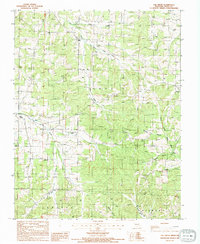
1987 Map of Elk Creek
USGS Topo · Published 1994About this map
The community of Elk Creek serves as a central landmark in this 1980s landscape, situated in the heart of Texas County. The terrain is defined by a dense network of waterways feeding into the Jacks Fork system, including the North Prong Jacks Fork and the Prong Jacks Fk. These streams and their tributaries, such as Harmon Branch and Peabody Branch, carve through the uplands where small settlements like Solo, Stultz, and Tyrone are connected by winding country roads. The map captures a moment in the late 20th century where the rural character of the Ozarks remains largely intact, anchored by the Elk Creek post office area and scattered Cem locations that mark the region's long-standing family ties. A single Substation near Tyrone provides one of the few signs of modern industrial infrastructure amidst the predominately agricultural and forested tracts of Cass and Sargent townships.
Find a feature on this map
19 named features on this map. Tap any name to fly to it.
Don’t see what you’re looking for? This feature index may not catch every label — zoom into the map to look around manually.
Map Details
Editions of this 1987 Elk Creek Map
2 editions found
Other maps of this area

1941 · Bado
USGS Topo · 1:62,500

1943 · Bado
USGS Topo · 1:62,500

1945 · Clear Springs
USGS Topo · 1:62,500

1948 · Clear Springs
USGS Topo · 1:62,500

1949 · Rolla
USGS Topo · 1:250,000

1951 · Raymondville
USGS Topo · 1:24,000

1951 · Cabool SE
USGS Topo · 1:24,000

1951 · Houston
USGS Topo · 1:24,000

1951 · Cabool NE
USGS Topo · 1:24,000

1951 · Cabool
USGS Topo · 1:62,500